It’s a good thing Boerne received plentiful precipitation during the first 11 months of the year because December didn’t add much of the wet stuff to help fill area aquifers.
In fact, according to the National Weather Service office in New Braunfels, the location that keeps track of Boerne’s weather, December’s rain total was the lowest of the year – and was so by more than an inch.
When the dust had cleared on the final month of 2021, and the year itself, Boerne had received 0.36 inches of precipitation at Boerne Stage Field. The average amount for December is 2.10 inches.
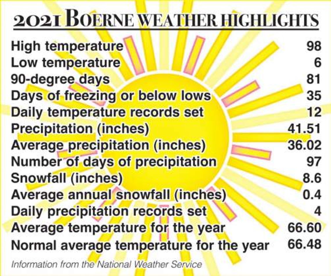
However, the overall 2021 precipitation total was 41.51 inches, or about 15 percent more than the typical year.
But December wasn’t only dry, it was warm as evidenced by an average temperature for the month being more than 10 degrees above normal. NWS statistics showed Boerne’s average December temperature was 61.1 degrees. The average is 50.3.
The average high temperature for the month was 72.7 degrees, or exactly 10 degrees warmer than normal. The average low was 49.5 degrees, or 11.5 degrees warmer than normal.
The mercury topped out at 83 degrees as the month and year prepared to come to an end – December 30. That reading did not set a record high for the date, but on four other days during the month, all-time record highs were established, including the 82 degrees reached on the last day of the year – December 31. The 82-degree highs on December 26 and 27 set records as did the 81 degrees on December 9.
The overnight low only twice dipped below freezing, hitting 27 degrees on December 12 and 28 degrees on December 13.
Weather records have been kept in Boerne since the beginning of the 20th century,
There were two other days when the temperature hit 80 degrees and another 14 where 70 or more degrees was reached. As far as the low temperature, there were seven nights when the mercury remained in the 60s, which were close to or above the normal high for those days.
The bulk of the precipitation fell on December 19, when 0.23 inches was recorded. It only rained on four other days during the month and combined to total only 0.13 of an inch.
The year
Boerne set seven new high-temperature marks in 2021, with the four in December accounting for more than half of them. The other three came in February and April when 83 degrees was recorded on February 5, 96 degrees was reached on April 10 and 91 was recorded on April 13.
However, as reported in an earlier Star story, Boerne thermometers never reached triple digits last year. The year’s high was 98 degrees, reached on consecutive days September 6 and 7.
The all-time high in Boerne is 112 degrees, reached on August 23, 1925.
Monthly highs for 2021 were 79 degrees in January, 83 in February, 85 in March, 96 in April, 94 in May, 95 in June, 95 in July, 96 in August, 98 in September, 90 in October, 82 in November and the 83 degrees in December.
On the other side of the thermometer, five record lows were set last year – and they all occurred in February around the time “Snowmageddon” hit. On February 15 and 16, the temperature plummeted to 6 degrees. The 12 degrees reached on February 17 also was a record, as was the 18 degrees hit on February 19 and the 12 degrees reached on February 21.
Before that powerful winter storm hit Kendall County around Valentine’s Day, it already was described as an “arctic blast that will bring some of the coldest temperatures the Hill Country has experienced in quite a while, as well as a good chance of some wintery precipitation.”
That storm delivered – and then some, landing the region and beyond in a deep freeze that lasted well into that week.
The first storm hit the weekend of February 12-14 with freezing rain and sleet falling until overnight Monday, February 15, when it turned into snow. In all, 5.5 inches of snow officially accumulated, a record for this century for a calendar day, according to the NWS. Three days later, on Thursday, February 18, another 2.5 inches of the white stuff blanketed Boerne.
The 8-inch total during the course of the week was the second-highest amount in history recorded during a seven-day period, trailing the 8.5 inches that blanketed the ground on January 23-24, 1926.
That winter storm was named The Star’s 2021 top story.
As far as temperatures, the 6-degree low experienced in Boerne during on February 15 and 16 were the eighth-lowest readings in the city’s history. And according to NWS statistics, those single-digit readings on those two days were the coldest temperatures recorded in Boerne since 1989.
Monthly lows for Boerne in 2021 were 24 in January, the 6 degrees in February, 32 degrees in March, 43 in April, 50 in May, 63 in June, 66 in July and August, 47 in September, 40 in October, 33 in November and the 27 degrees in December.
The all-time low temperature recorded in Boerne was minus-4 degrees on January 31, 1949.
Overall, January was slightly warmer than normal, February was significantly colder, March was a little warmer, April was a little cooler, May was cooler, June was a tad cooler, July was cooler, August was a little cooler, September was warmer, October was warmer, November was slightly warmer and December was significantly above normal.
Besides “Snowmageddon,” the only other real weather story last year was May and the 12.39 inches of precipitation that was recorded. That amount accounted for almost 30 percent of Boerne’s 2021 precipitation, and it fell in buckets on several days as six times more than an inch of rain fell on any given day, including 2.88 inches on May 29.
On two days that month, Boerne daily precipitation records were set with 2.08 inches falling on May 2 and 1.79 inches accumulating on May 19. The 2.88 inches on May 29 was not a record for the day.
There were two other days last year when single-day precipitation records were set – 2.07 inches on July 7 and 2.74 inches on October 14.
The record amount of precipitation ever recorded on a calendar day in Boerne was 9.04 inches on October 2, 1913. The most annual precipitation the city has recorded this century was 62.41 inches in 2002. The least amount was 14.74 inches in 2008.
The National Weather Service predicts the first three months of 2022 will be warmer and drier than normal.
After Sunday’s high temperature of 83 degrees and the overnight low into Monday dipping to 23 degrees, the short-term forecast calls for daytime highs in the 60s and 70s during the middle portion of the week, cooling to the 50s on Friday. Lows are forecasted to be in the upper 20s to low 30s during the period.


Comment
Comments